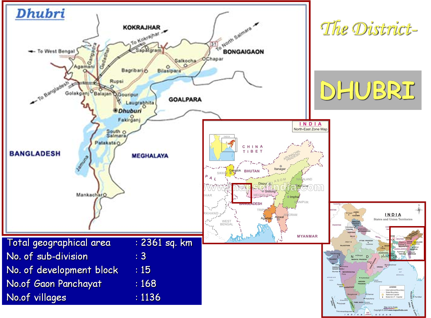
Dhubri district falls under Lower Brahmaputra Valley agro-climatic zone and is located at a distance of 283 km from state head quarter. The district is bounded by Kokrajhar district in the north, West Bengal and Bangladesh in the west, Meghalaya in the south and Meghalaya and Bongaigoan district in the east. The river Brahmaputra flows through the district roughly from east to west, dividing the district into two parts- north bank and south bank. The river has innumerable tiny islands (Char) created due to frequent change of its course. Besides Brahmaputra, there are several other rivers like Champavati, Gaurang, Sankosh, Tipkai, Gadadhar, Gangadhar in the north bank and river Ginziram and Kalo in the south bank. The total geographical area of the district is 2361 sq km. The district has a varied topography of high, medium and low-lying area. The district has three civil Sub-divisions viz. Dhubri, Bilasipara and South Salmara-Mankachar. There are 15 Dev. Blocks, 168 Gaon Panchayats and 1136 revenue villages in the district
2. GENERAL STATISTICS :(i) General Information about Dhubri District :
The total population of the district is 1948632 (Census 2011) out of which 97.23% belongs to General Caste, 2.66% Schedule Caste and a negligible percentage of Schedule Tribe population which is only 0.11%. The number of female per 1000 male is 954. Under 168 G.Ps in total, there are 1136 revenue villages out of which 68 are uninhabited. The reason of uninhabitation is mainly complete erosion of the villages by flood & river Brahmaputra.
(ii) Land Utilization Statistics :The geographical area of the district is 236126 ha out of which 61% (144152 ha) is cultivable area (net sown area + culturable waste + current fallow). Out of the total cultivable area 90% (130034 ha) is at present under cultivation (net sown area).
(iii) Land Capability Classification:Based on soil texture, soil problems like erosion, undulation, siltation, water table and productivity, the land holdings have been categorized into different classes of land capability. Because of proneness to flood, soil erosion, siltation etc. only 4.2% of the total land holding belongs Class I land. However, 36% and 33% of land holdings belong to Class II and Class III respectively.
(iv) Land Holdings Pattern:Total land holding of the district is 193270 ha with a cultivable area of 144152 ha out of which 130034 ha is net sown area.
(v) Soil fertility indices/Problematic soil:There is no available data based on soil sample analysis regarding organic Carbon, N, P, K, and other micronutrient content of the soil in the district. However in general, soil of the district is acidic in reaction. Soil of major areas are mildly acidic (5.5-6.5 PH), while soil in high land old alluvial is severely acidic. There is a problem of riverbank erosion in the riverine tracts, specially during flood season. This problem is more acute in South-Salmara Sub-division. Table -5 shows the block-wise area affected by acidity and soil erosion.
(vi) Micronutrient Status:Soil sample analysis for determination of micronutrient content in the District is yet to be undertaken. However in some areas of all the dev. block mild deficiency of micronutrients specially boron deficiency has been observed.
vii) Agro-ecological situation:Based on rainfall, physiography, soils, occurence of flood and cropping pattern the district has been delineated into four different agro-ecological situation with a view to generate location specific technologies to meet the specific needs of the farmers. 32.63% area of the district falls in char land(AES-IV); 32.28% in old riverine alluvial plains(AES-II); 17.67% in flood prone recent riverine alluvial plains(AES-I) and 17.42% in high land old alluvial(AES-III).
(viii) Information on Climatic condition:Present district data on rainfall, temperature and humidity is not available. Taking the five years average, the monthly minimum temperature was observed 12.25.0 C in January. Similarly the average monthly maximum temperature observed 31.78.0 C in May. The five years, average annual rainfall in the district is 2176 mm ranging from 1808 mm (lowest) in 2003 & 888 (highest) in 2005. The rainfall pattern observed dry during November to March (winter) with an average annual rainfall of 97 mm only while April to October was observed as wet period that received the average annual rainfall of 2079 mm. Due to varied distribution of rainfall, the district suffers from heavy flood during wet period and moisture stress in the dry period. Analysis of rainfall data presented in Table -7 shows that out of 104 average annual rainy days, there are only 10 rainy days during the period of November to March and the remaining 94 rainy days during the period of April to October. Relative humidity was highest during June & July while it was the lowest during February & March. High relative humidity coupled with high temperature during summer favours the growth of jute & paddy in the district.
3. CROPS/BREEDS/FISHERIES/ ETC. ACTIVITIES IN THE DISTRICT:(i) Agriculture Crops:
The District favoured by desirable soil and climatic condition grows a wide range of crops. Paddy is the main crop of the district, grown mainly as summer and winter paddy. The other major crops are Mustard, Jute, Potato, Wheat, Lentil, Black gram and different vegetables like Brinjal, Cabbage, Cauliflower, Ladys finger, Radish, Tomato, Cucumber, Carrot and Guards. Onion, Garlic, Chilly, Zinger and Turmeric are also grown in small areas in all the Dev. Blocks. Some other minor crops are pea, sesamum Niger , Cucurbits, Pineapple, Tapioca etc. Important plantation crops are Banana, Coconut, arecanut, guava, mango, lemon, bamboo etc. At present cropping intensity of the district is 203%. 18% of the net sown area is under mono cropping, 61% under double cropping and 21% under triple cropping.
(ii) Animal Husbandry and Veterinary Commodities:Animal Husbandry is one of the core sectors of the district economy. It provides opportunities for poverty alleviation, development of rural economy, combating rural unemployment and abridges the increasing gap between poor rural and affluent urban society. Rearing of indigenous local breed of cows and buffaloes for milk purpose is common practice of the farmers. But now a days, a large number of farmers have started rearing cross breed cows and murrah buffaloes . At present 80% of the districts milk production is from local cattle breeds and rest 20% from cross breeds. In all parts of Dhubri district, irrespective of agro- ecological system, sheep and goats are reared mostly for meat purpose. The available goat breeds are Assam Hill and Black Bengal Goat. They are well adopted in low input management system and adverse climatic conditions of the district. Sheep and goats are mostly reared in backyard system; but now a days, many rural youths are coming up to undertake goattery as a commercial venture.Pigs and poultry are reared mostly in backyard system; although good numbers of commercial broiler farms are rising up now a days.
(iii) Fishery:Fishery is another important enterprise next to Agriculture and animal husbandry. With the changing trend of fish rearing method and economic profitability, the fish farmers are organising themselves in the form of fishery S.H.G., C.I.G., fisherymen samiti etc. and are adopting integrated fish farming like horticulture cum fish culture, paddy cum fish, pig cum fish and pig-fish-horticulture.
| Total geographical area | 2361 sq. km |
| No. of sub-division | 3 |
| No. of development block | 15 |
| No.of Gaon Panchayat | 168 |
| No.of villages | 1136 |
| Total population | 1415371 |
| Population density | 585 |
| Sex ratio (female/1000 male) | 947 |
| Population growth rate | 23.63% |
| Total no. of household | 297121 |
| Total literacy rate | 48.21 % |
| Per capita fertilizer consumption | 432 g/cultivator |
| Per capita power consumption | 0.03 MWH |
| Forest area | 39776 ha |
| Not available for cultivation | 70597 ha |
| Other uncultivated area | 9478 ha |
| Fallow land | 16803 ha |
| Net sown area | 142243 ha |
| Gross sown area | 207084 ha |
| Area sown more than once | 264841 ha |
| Cropping intensity | 203% |
| No. of cultivators | 174991 (Male= 157069; Female= 157069) |
| Agricultural workers | 111890 (Male= 93867; female= 18027) |
Click here for more about Dhubri district